"Innovative, green, inclusive and fair" - Istanbul pedestrian project successfully implemented
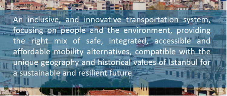
As it is outlined in Istanbul Metropolitan Municipality's (IMM) vision, “we are working relentlessly to make Istanbul an innovative, green, inclusive, and fair city”. This vision was reiterated with the Istanbul Sustainable Urban Mobility Plan (SUMP) which aims to enhance quality of life and mobility. This new mobility strategy is stregthened with the pilot projects implemented in many different points within the city. The Laleli pedestrianisation project is the crucial and impactful one in this regard, because of both its historical and commercial importance.
In this article I am presenting both a bottom-up shared vision, which aims to create participatory and inclusive projects as well as valuable insights from short interviews with the City of Istanbul transportation managers and the Eurovelo Team.
Pedestrianisation Project in the City of Istanbul
IMM is responsible for the local administration of the entire provincial territory that spans a total area of 5,343 square kilometres. The City of Istanbul's daily number of trips, including pedestrians, private cars, public transport and shuttle services (schools and personnel), is 30.3 million. Plus, Istanbul is an attractive point for many different actors in terms of economy, culture, tourism and industry as well.
The Laleli zone is an important part of the historical peninsula of Istanbul, recently named as the historical peninsula. A pedestrianisation project was designed in this area by IMM's Sustainable Urban Mobility Office through the Global Future Cities Programme. The pedestrian zone, which spans a total area of 622,000 square metres and consists of a main avenue onto which a tram line passes and 28 streets, is closed to private, logistical and tourist vehicles from 10.00 am to 09.00 pm. Taxis, commercial and tourist vehicles are allowed to enter into this zone 2 or 3 times in a day between determined time slots. The Laleli pedestrianisation project demonstrates what a resilient, livable and human-centric city can look like to citizens and stakeholders as well. The limited zone may have impressive impacts on city transportation planning beyond its physical borders.
The project is part of the Istanbul Sustainable Urban Mobility Plan (SUMP), which was finalised in March 2022 and aims to enhance the quality of life and mobility in the city. Transportation planning across the functional urban area started being shaped by SUMP and shifted from a car-oriented paradigm to a human-oriented view. This shift fits with the broader IMM vision, to "work relentlessly to make Istanbul an innovative, green, inclusive, and fair city."
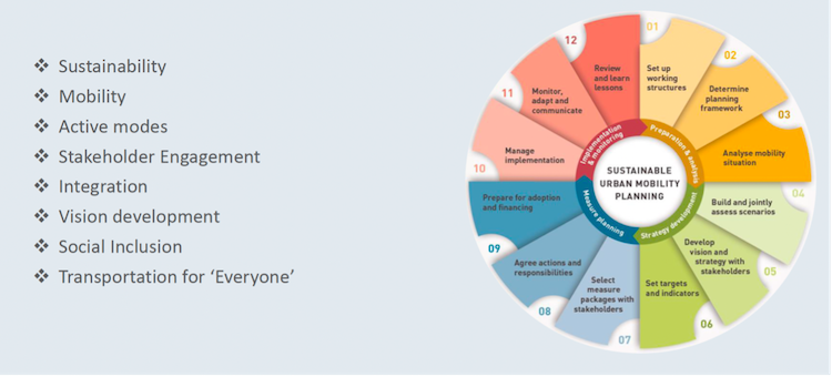
Istanbul SUMP Focus Points
Implementation
During the preparation process of the project, IMM carried out a participatory and inclusive process with citizens and local stakeholders, including the Laleli Industrialists and Businesspersons Association (LASIAD), The Union of Hotelies and Fatih District Municipality (where the Historical Peninsula is located in). This participatory and inclusive way of acting is one of the priorities of IMM according to its vision. After its implementation, the monitoring process is going on and in collecting feedback we are working to make the Laleli zone more livable. All these efforts, which demonstrate how to operate a human-oriented public realm and mobility structure in the city, help to create a resilient city and smart transportation. In this context, the implementation decision of this project was taken in November 2020 by UKOME (Transportation Coordination Centre), which performs planning and coordination duties by making decisions regarding transportation and traffic within the jurisdiction and responsibility area of the IMM. Redesigning street landscaping planning and its tender will be completed by the end of the second quarter. On the other hand, an interactive tactical urbanism practice, which aims to make Laleli a pedestrian and bicycle friendly district, will be implemented in the Laleli zone in the first quarter of 2022.
This project contributed to a decrease in noise and visual pollution in the implementation area so that more people come and spend more time in the area, increasing commercial potential. This result was reflected in a speech by the General Secretary of LASIAD, which has has more than 700 members in Laleli. The General Secretary noted that commercial intersections began to increase and touristic visits as well after the implementation of pedestrianisation.
This project was applied for the first time under Covid-19 circumstances, which altered traffic flows and habits throughout the world. Tourist travel decreased, which is relevant to this project, as it aims to make a low-carbon zone in the historical Peninsula, with its famous Blue Mosque, Aya Irini Church, Basilica Cistern, Hagia Sophia, Grand Bazaar and Topkapı Plalace. Each of them has particular importance issued based on their own historical past, and lots of them are in the UNESCO Cultural Heritage List. The Historical Peninsula is a place where visitors see Byzantine and Ottoman heritages and a junction point of ancient history and modern city patterns.
This kind of implementation projects are both supported top down within the Municipality and are shared interactively with citizens, so subsequent projects will make us closer to a communal vision.
Istanbul SUMP Vision
Members of the IMM provided insight into the pedestrianisation project, the importance of the historical peninsula and the participatory aspect of the implementation process.
|
İ. Orhan Demir: “The historical peninsula is very important to us and we will restore it to give its former identity back.” |
İ. Orhan Demir, Advisor to the Mayor, Istanbul Metropolitan Municipality What is your purpose about the historical peninsula? The history of the historical peninsula goes back 5000 years with archaeological excavations. There are lots of historical monuments and pieces that are unfortunately ruined or completely damaged. The area is very important for both Istanbul and the world. What we want is for the historical peninsula to highlight both the former identity and touristic dimension. We need to apply a congestion charge zone, which is one of the precautions of reducing private car use as it is applied in the metropolitan areas of some cities in the world. Since the historical peninsula has natural borders from the fortress entrancesand bridges between the Pera zone and the historical peninsula, a congestion charge zone is easy to apply. |
We need to propose public transportation options that are faster and more comfortable instead of private car use. We have already four rail lines including Marmaray, T1 Kabataş-Bağcılar Tram Line, M1 and M2 Metro Lines; besides these we are planning to apply dedicated bus lanes too.
All new implementations have to rely on legal pillars and aim to target public interest. We are developing a parking policy in order to make parking more expensive or impossible to the people who are not residents of the historical peninsula. Beside this, we need to implement park-and-ride features around the historical peninsula in order to get traffic flow calmed. Plus, we need to remove the transit passes from here. After all these are successfully completed, the historical peninsula will be a low-carbon zone and a more walkable and cyclable area for all.
There is a certain distinction in this historical peninsula in terms of land use. A certain part of the historical peninsula, Atatürk Street, is mostly used in the day; another part, Topkapı side, is a residential area that turns into a deserted area in the night time. We need to make the historical peninsula more livable during the day.
Lastly, we will be implementing an exposition in order to present all finished, ongoing and future projects on the historical peninsula at the Beyazıt Square. Citizens will be able to see future project plans and will be able to give feedback.
 |
Utku Cihan, Head of Transportation Department, Istanbul Metropolitan Municipality What is the importance of the historical peninsula from your side? The historical peninsula is an important area in terms of history, commerce and tourism for both IMM, Istanbul and the rest of the world. Our goal is to harmonise all these functions together. |
In this area, there is a pressure to solve the issue of noise and air pollution, caused by private and commercial vehicles. We carried out a pedestrianisation project in Laleli district, where we aim to deescalate the mentioned issue. During the project implementation, we received positive feedback from shop owners, business executives and citizens. This project should be spread out all over the historical peninsula, not just in Laleli district. We need to enhance public transport including all railways, rubber-tyred vehicles and sea transport modes for this purpose. We aim to raise both electrical vehicles usage and its accessibility. Beside this, we have projects on traffic congestion pricing and low-emission zone areas. This zone, the historical peninsula, will be gradually turning into a more livable zone with the pilot projects.
During Laleli interactive tactical urbanism practice
Do you have an idea to create different hubs in Istanbul?
Istanbul is a polycentric city, and there are also sub-centres in the districts. We say we will give support to the district municipalities as much as we are capable of. District municipalities also have a positive view on prioritisation of pedestrianisation. So, we have decided to pedestrianise 15 streets that we are implementing together with the district municipalities. We have some future projects in Pendik, Şişli and Osmanbey districts and ongoing pedestrianisation projects, e.g. child-friendly streets, healthy streets, which are temporary or permanent. There are 30 district municipalities in Istanbul, and at IMM we prioritise pedestrianisation projects all over Istanbul. We are aiming to create a holistic transportation system which prioritises the pedestrian.
A pedestrian master plan is being prepared, because a robust strategy is needed before any implementation. The pedestrian master plan reveals this strategy and we do it by following a participatory method. IMM's studies on walking are being prepared together with all stakeholders. Pedestrian chief works for safer and more comfortable transportation. In traffic prioritisation pyramids, the pedestrians come first with active mobility modes.
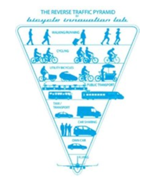
Traffic prioritisation pyramide (Source: https://www.researchgate.net/figure/The-reverse-traffic-pyramid-Source-Bicycle-Innovation-Lab_fig1_328748845)
While SUMP was preparing, the Sustainable Urban Mobility Office, Bicycle Chiefdom and Pedestrian Chiefdom were established within the Transportation Department in order to make both inclusive implementation projects and enhance active mobility modes establishing seamless transportation.
“Laleli, slow down and discover!”
Laleli interactive tactical urbanism practice, which is the result of inclusive pedestrianization process in the historical peninsula, is mainly designed by Eurovelo Team. Could you please explain how did you apply this and what did you learn during this activity?
Engin Aktürk, Eurovelo Coordinator, Istanbul Metropolitan Municipality
First, we did fieldwork and literature surveys in order to comprehend the historical peninsula zone. After that, with the participatory and inclusive interactive tactical urbanism practice we provided a street that could be used more efficiently than before. During the activity we were able to enhance the quality of life of the citizens with the parklets and bicycle lanes.
In the first stage, a 'discovery and infographic workshop' with 6 facilitators and 18 participants was organised under the leadership of the Give Voice to Your City team, with the theme of "knowing the space and the users", with the aim of collecting the mobility data in the area, evaluating the uses and presenting them to the public. Six different infographics were produced and published from the interdisciplinary workshop, which lasted about a month. After that, we created more walkable and livable spaces through tactical urbanism examples during the Laleli interactive tactical urbanism practice that lasted five days.
We learned who uses this area by means of both the infographic workshop and interactive tactical urbanism practice. Here is the place for temporary users and a passage route for tourists. We also learned which transportation mode people use here. The green belt was the most expected point in our survey and interactive implementation. On the other hand, both children and older people come more on the scene than tactical urbanism application.
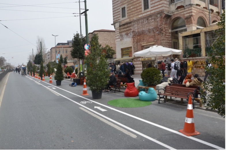
Temporary bike lane implementation and parklet along the Ordu Street in Laleli
Merve Akdağ, Eurovelo Coordinator, Istanbul Metropolitan Municipality
We developed the event with a participatory approach within IMM, from the idea stage to the implementation. In the implementation field, all inner stakeholders, the Transportation Planning Directorate, the Green Areas Park and Gardens Department and the Traffic Directorate worked in close coordination. We received very positive feedback from all directorates and units that we evaluated and presented the event results. We have seen that an effective, social benefit-oriented and low-cost mutual communication system can be established between the teams serving and the people receiving service with the tactical urban planning practices to be made in this way regarding Istanbul urban areas and mobility plans.
Engin Aktürk, Eurovelo Coordinator, Istanbul Metropolitan Municipality
With the Slowdown and Discover activities, the first of which was held on Laleli Ordu Street and its surroundings, it was aimed to develop a participatory and inclusive program. We learned who use this area by means of both infographic workshop and interactive tactical urbanism practice. Here is the place where temporary user and passage route for tourists. We learned also which transportation mode people use here? Green belt was most expected point in our survey and interactive implementation. On the other hand, both children and older people come more on the scene than tachtical urbanisme application.
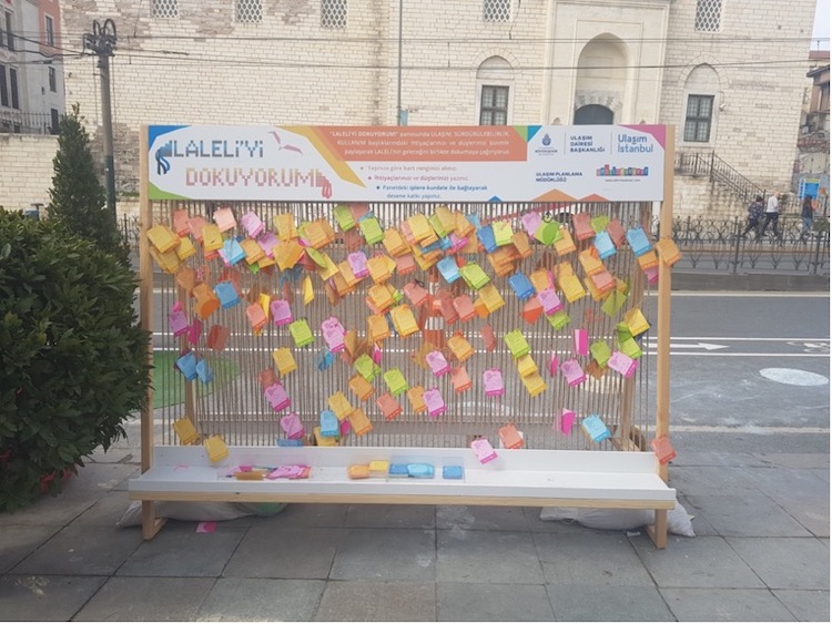
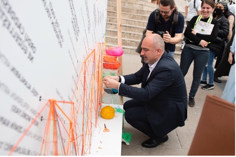
An interactive panel “weave the Laleli” to get citizens’ ideas. The post-its hang on by the citizens as if a carpet knot
What were the differences at the activity field, if you compare before and after?
Merve Akdağ, Eurovelo Coordinator, Istanbul Metropolitan Municipality
In one of the lanes closed to traffic on the Ordu street, resting and spending areas were established by greening with Superpool designs, and the pavement was widened. It was a tactic for people to have a safer and more enjoyable time.
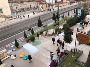
A view from Laleli Ordu Street, while implementing
There was a perception about why the street was closed to traffic in the area and the pedestrianisation practice gained meaning for people. Also it was seen how the gap between the decision and implementation phase could be evaluated efficiently. Motorised terror affecting pedestrians in the area was reduced by 60% thanks to the temporary bike lane implemented during the event. Space usage by young and old people has doubled. The traffic speed doubled during the implementation compared to the situation before the implementation, and the number of passing vehicles increased. Birds came to the green pots and shared their songs. Especially the children who were not visible in the area showed great interest in Oyun İstanbul (which aims to make Istanbul's playgrounds and recreation areas) events. The rate of people chatting has increased around the street. Artisans’ ticket sizes have increased as people spend more time on the pavement. We learned through the panels that the users wanted more access to cultural heritage and green areas. The implementation’s satisfaction rate in the environment is still receiving positive feedback at 92%. Since the field implementation has been lifted at the moment, we are informed that local tradesmen and residents want a re-implementation in daily transitions from the field.
Before/After Figures- Impact Assessment
|
Before |
After |
|
In total, the hourly average number of vehicles passing by was determined as 424. |
After the implementation, an average of 537 vehicles started to pass. (especially taxi and motorbike) The increase in the total number of vehicles is 27%. |
|
E-Scooter: 20 km/h Motor-bike: 41,64 km/h The highest speed: 79 km/h |
The decreasing of Motor-bike speed is 32%. Motorcycles traveling below 30 km/h after the implementation has tripled. |
Partner
Arup
Country
Republic of Turkey
City
Istanbul
Themes
Mobility
Strategy & Planning
Author(s)

Şükriye Tümay Erdil
Project Manager at the Sustainable Urban Mobility Office, Transportation Department, Istanbul Metropolitan Municipality